
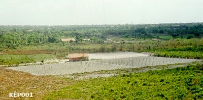
Remote Viewing Dossier: HAARP-like Facility (Target KÉP001)
Date: August 31, 2013
Session Date: August 24, 2013
Viewer: MW
Monitor: HunViewer
Target Type: Photograph
Tasking Objectives
Describe the content of the target image.
Determine the possible location of the target.
Identify the target’s function or purpose.
Session Summary
The perceived environment appeared dry, parched, and desert-like, not sandy, but composed of stony, gritty soil with sparse vegetation. The immediate surroundings were plain and characterless.
The main structure within the target seemed to be a facility designed to emit and receive energy or signals from regions beyond the Earth’s surface. (AOL: The structure may relate to astronomical or meteorological activity.)
(AOL: Possible location impression: Cheyenne?)
The facility’s radiating activity was perceived as directed toward a specific distant point, possibly in space. It appeared to be one component of a larger, globally distributed network, forming an approximate pentagram-like configuration across several continents. (Example map here >>)
Personnel impressions included a small, highly skilled crew wearing grey-green and orange uniforms without insignia. They worked in a subterranean control room with advanced instrumentation, described as complex dashboards and control panels.
(AOL: Resembling a control room of a nuclear power plant.)
The control area appeared to be underground, consisting of at least three levels, with the third level being the most significant operational area. Signage reportedly contained Roman numerals and non-Latin characters, suggesting a unique or coded symbolic system.
Global Distribution Impressions
Perceptual data indicate that similar installations exist on multiple continents, forming an interconnected global network.
Primary site impressions include (later, from the feedback information):
New Mexico, USA
Western South America, extending northward toward the Atacama Desert
Northern North America, particularly northwestern Canada or nearby regions
Manchuria and China
Northern Norway
Japan, and islands or peninsulas located south of Indonesia
Additional smaller facilities may exist worldwide, possibly serving as secondary or auxiliary nodes in the network.
Information Stream Notes
The data stream associated with target KÉP001 revealed details consistent with a global communication or energy-transmission system.
Session ended.
The specific site referenced in this session was identified as a facility near the São Luiz Space Observatory, São Luís, Maranhão, Brazil.
Conclusions
The remote viewing data suggest the presence of a global system of energy or signal-emitting facilities, interconnected and possibly coordinated for atmospheric, ionospheric, or experimental purposes.
The São Luiz site in Brazil may represent one operational element within this network. [1]
Cover image: nexojornal.com.br